|
Barnes's Canal Cutting - Safety Issues & Loss of Amenity The first part of this page describes the design and layout of the canal and tunnel, finished in 1805, and the second describes what has happened, or appears to have happened, to create a hazard for the Stoke Road. |
||
 |
The Grand Junction Canal, including the tunnel
through Blisworth Hill to Stoke Bruerne, was completed in 1805.
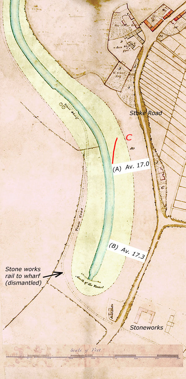
The map below, from Grafton's survey in 1838, shows the south-western
part of Blisworth including the mouth of the tunnel. In the
process of achieving alignments the chief engineer of the project, James
Barnes, had set the level of the canal in Blisworth at about 90 metres
above sea-level (there are no locks in Blisworth). He also
presumably positioned the canal a sufficient distance from the twin
cottages (6 & 7), which once faced onto a green, so that the slope of the ground in the cutting for the canal would
not exceed 20º. As the road previously passed roughly over
the position of the tunnel mouth, he must have rebuilt the road to be
close to the cottages. Indeed it appears that he was constrained in
that the canal could not have been placed any further towards the east
because of the cottages. Modern Ordnance Survey bench-marking
places the road at a height of 106 metres near location (A)
and, by survey about 107 metres at location (B). Simple calculation
using the scale for the survey map reveals that the average slope angle
for the cutting in both locations was about 17º and these results
are shown on the map. This calculation relates to the water
surface, road surface and the edges. Given a 6 foot towpath higher
than the water and a grass margin of 8 foot to the roadside, the average
soil slope would have been 0.2º larger. Thus Barnes ensured
that he abided by his own design rule. It is noted in the company
minutes, c. 1800, that Barnes energetically resisted increasing the rule to 30º in order to save digging out so much soil, rock and clay in the
vicinity of the tunnel mouth. There are archive
pictures, taken
1890 to 1940, that appear to confirm a reasonably uniform slope. The map also shows land ownership for 1838; the areas tinted pink were Duke of Grafton land, otherwise the area belonged to the original canal company, GJCCo. At the sale of the majority of the Grafton Estate in 1919, for reasons of death-duty, there is no record of how much of the slopes area was acquired by the GJCCo. |
|
|
For example, did
the Parish or County Council insist on acquiring a strip of land
adjacent to the Stoke Road in order to fulfill the general requirements
of maintaining the road, whatever requirements were thought appropriate
for that purpose in 1919? It is beyond the scope of this paper to
comment on County Council land-holding in the period 1919 to 2000 but,
regarding the Parish Council, there were requests sent to the GJCCo., to
T.W.Millner in fact, from 1907 to
1919 to repair the fence by the Stoke Road, with the implication that
the GJCCo. "owned" the land and trees up to the road well before the
estate sale. This correspondence warrants a detailed examination
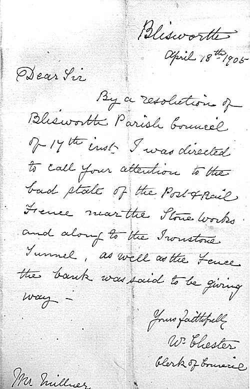
from the "GJCCo. side" and attempts are being made to do this. In the N.R.O. there is an
assortment of letters both to and from Millner and it is clear that the
County Surveyor also wrote to him about the state of the fence. In
the earliest Parish Council letter of 1905 it was pointed out that
"the bank was giving way as well".
In 1915 Millner received a reply to his letter from his boss instructing
him to continue patching the fence and when the war is over "we
will consider some ferro-concrete fencing". Ownership of land
and fence seems implicit. Incidently, the boat stable shown may
also be visible in an early picture of
sailing on the canal.
Today's Canal Cutting
|
||
|
Comments on the Embankment profile |
||
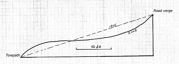 |
Result of a Mini-Survey Today there is a variably wide plateau in the soil of the slopes to the east of the canal and this is noticeable for 100s of feet running north/south in the vicinity of both locations (A) and (B). The possession of an elementary optical level gauge has allowed assembly of a representative profile for the slope and this is shown in the diagram to the left, being very much an estimate. At both ends of the soil profile the slope exceeds 45º and it is obvious that the road could be being destabilised by such a profile. | |
| On entering the area by path from the south end, the first impression is that the land has slumped down maybe 3 metres near the road. Could it also have slumped towards the canal (and be washed towards it by the weather) and be lost from the site in the form of dredged out mud? Could it have been excavated and used elsewhere? Perhaps no-one has been watching this area over the years so a precise answer cannot be given. However, there is gained a very definite impression, particularly from the roadside, that much soil or clay has been lost over the years. At one location there is a pile of moss-covered blue clay (marked 'C' in the map, 5 to 10 tonnes), evidently pushed together by a vehicle, which suggests that one reason for alteration to the slopes profile might have been in moving and/or in removing clay. At another there are old tracks, marked in red, left by some sort of tractor vehicle but for what reason cannot be stated for certain. Whatever has been going on, the plateau in the profile gives the impression of being man-made and features like some crevices suggest being probably a result of that disturbance. The lower 'bulge' near the towpath is simply not there in archival photographs taken early in the 20th century with a vague suggestion that some movement was seem by 1960 - see links immediately below. No similar profile changes have been noticed on the other side of the cutting. | ||
|
|
There are relevant archive pictures on the
website, for instance: Near towpath profile, 1925 Near towpath profile, 1930 General, c. 1925 also in 1944 Opposite slope c. 1930 Access from Road, 1950 Near towpath profiles, 1960 |
|
|
It has been 200 years since the gently sloped sides of the cutting were
formed. After 100 years a councillor notes in 1905 that the bank
has given away (somewhat?) and this can be taken as the result of clay
movement due to its weight and its water content. An old-timer
recalls as a boy in the 1930s that the lower slopes were grassed and
joined the towpath without a step as shown in archival pictures.
He remarks that there was some "drop" at the top that was too
inconvenient to walk down by. But at the ironstone railway and at
the bend in Stoke Road there was a well worn path straight down to the
towpath from the road. He said that on some summer days there were
dozens and dozens of people just messing about or relaxing "under
the trees" - an idyllic scene that will never return. Since
the cutting was dug in blue lias clay, which tends to support briars,
ivy and moss &c., the grassed area must have been encouraged originally by
applying a layer of more loamy soil. Such fertility has gone -
further evidence that a simple 'slump' movement alone is not a
sufficient explanation of what has happened.
On the assumption that the physical condition of the clay slope and the effects of nature in the last 50 years were the same as in the first 150, we would expect some worsening of the subsidence at the top of the profile, after the 50 years, but little change at the bottom near the towpath where a grassy area of uniform slope should still be seen.
Fortunately there have been more photographs which have come to light and an approximate account of the modification of the profile of the embankment over the last 200 years is given in a separate document that concentrates on the future welfare of the road. It has been pointed out to me by John Mallard that many of the trees in the recent photos above are leaning towards the canal. As trees tend to grow vertically, this indicates that the surface profile has changed during the lifetime of the trees. This detail is consistent with the account. Tony Marsh 28 January 2008 |
||
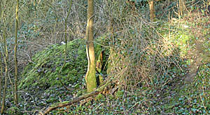 The moss-covered clay heap referred to above.
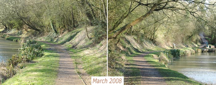
