|
The history of the Canal Embankment
Profile and Tony Marsh - first posted April 2009
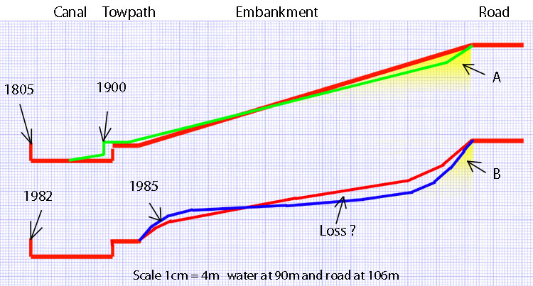
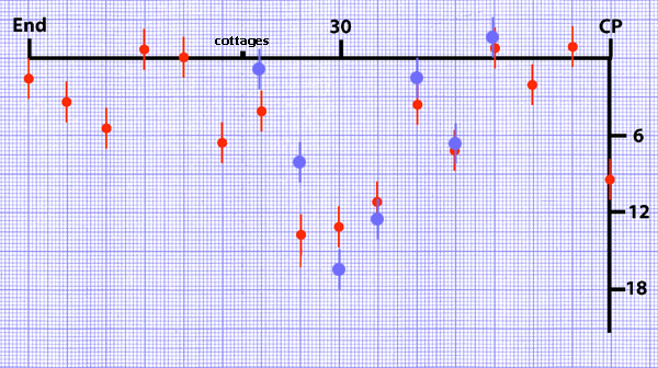
The comments below, against each of the four profiles shown above, constitute a theory to explain the profile changes in the canal-side embankment by the north portal of Blisworth Tunnel. The change since 1805 is of course irreversible and has led to a certain loss of amenity near the towpath (whose width has been accidentally exaggerated above) and a concern for the stability of the road surface which has required attention twice in recent years. This document finishes with an amateur assessment of the road surface profile with the intention of comparing it with new data taken at one year intervals in the future. 1805 The heights above sea-level of the canal water and Stoke Road (near Greenside) are 90m and 106m respectively. The red line shows a straight profile between the two levels as this is what one imagines the engineer James Barnes would have ensured. The subsoil is mostly blue clay yet a grassy bank populated with trees is evident by 1900. The blue clay must have been covered with some top soil. There is no photographic record of the profile at this date. 1900 Some slump was observed by councillors at about this time in the ground near the road. Common sense suggests that a clay mass over a long period would slump and tend to make the canal narrower. The green line shows this effect schematically. Periodically, some dredging and trimming of the towpath would have maintained canal width so that by 1982, when the last known major dredge was carried out the canal width is shown restored. There is ample evidence of a steady transition from grassy bank to towpath from this time up to 1940. 1982 Maintaining canal width involves putting material back onto the bank. The red line thus shows a bulge near the towpath and shows also considerable progress on the slumping of the bank near the road. By this time there was some removal of trees (local lore!) on the bank which could have worsened the rate of slump. What happened in 1982 was the preparation of the area around the tunnel mouth for the tunnel repairs project. The towpath was once again cleared partially to allow small vehicle access along it. This photograph (in the tunnel repair section) shows the shaping of soil near the towpath immediately prior to draining the canal for lorry access into the tunnel. How the red line shows the slump near the road is the result of guesswork. 1985 By the end of the tunnel repairs there was a picture taken which shows that the banking near the towpath had been increased since 1982. Relatively recently it has been observed that this banking has been 'over-dressed' with some blue clay (it was brown earth in 1985 but stubbornly supports mostly moss at present). In walking around the area it strikes one that (a) blue clay has been moved around at some point (perhaps in the 1980s), (b) the surface in much of the embankment area is now nearly level and (c) the slumping near the road is at 45 to 60 degrees over much of the length of the road as it passes by the embankment area. In the rather level central region it is tempting to think that blue clay has actually been taken away - hence the indicator 'Loss ?' in the above schematic. In some correspondence last year, British Waterways people tell me that no material would have been taken away and that the profile slumping is due mainly to perfectly natural processes, partly accelerated by surface water from and/or through the road resulting in a softening of the clay, and that may all be correct. Since 1985 the Stoke Road has been repaired twice because of its slumping. There has also been installed a traffic safety barrier because of the hazard presented by the considerable drop adjacent to the roadside. A comparison of the triangular sections of clay and/or earth shown in the schematic above, labelled 'A' and 'B', suggests that the foundation of the road is supported laterally far less now than it was in 1900 thus promoting more freedom for the clay beneath the road to be compressed by the weight of traffic and be squeeze laterally. Compared to 1900, of course, the traffic can now include vehicles of weight up to 44 tonnes instead of being typified by a loaded horse and cart. Following what was purely a hunch really, it was thought wise to sample the tilt of the Stoke Road, each year, in an amateur data-collection project using a spirit level. The diagram below tells us what the average 'camber' of the road surface is, towards the embankment, at regular intervals of about 20 yards. It is expressed as inches of level difference across the road and the traces are dated April 2009 (data points in red) and March 2010 (data points in blue).
"End" refers to the end of the safety barrier nearest to Greenside, "30" to the speed restriction signs at the allotment entrance and "CP" to the first encountered edge of the tunnel car-park. The road is 5.5m wide and the spirit level is 36" long. Consequently the scope for errors in readings just taken at the midline of the road is considerable - the 'error bars' just relate to the job of reading the bubble. For readings that translate to over 12" the bubble is very near its indicating limit and so a modified level was used to check the results. The readings taken between the 30 and the cottages may change because the road may need repairing there around some works on drains. In addition, it was noticed that the centre line of the road where the major repairs were made in 2002 there is some separation and a drop in the level indicating the opening of a fissure in the foundations. No conclusion can be reached until some comparisons can be made, other than the camber is quite noticeable at the gentle corner by the allotment entrance and it is unlikely the road was built that way. Changes over the eleven months April 09 to Mar 10 are not really significant considering the crudity of the measurement technique. The NCC made an assessment of the road by surveying in early February 10 and therefore now have a baseline. This assessment shows that despite the appearance of cracks in the centre of the road by the cottages there has not been much change recently to the general tilt of the road. In November 2010 the NCC decided to fill the central cracks with a tar sealant to prevent frost damage during the winters. By the end of January 2011 there were narrow cracks developing next to the filling. It is thought that the NCC engineers are becoming worried by the heavy vehicles that are routinely using the road and that NCC have commissioned regular theodolite measurements checking for subsidence. Latest news - February 2011: Over the past year, a drought year, the edge of the road nearest the canal is reported to have moved downwards by a very small amount and outwards, towards 'oblivion', by roughly half-an-inch. In fact, half the road seems to have made this outward movement to leave a gap along the centre line of about the same amount - as could be clearly seen to all who passed that way. A continuing survey is essential to aid interpretation and in particular gauge the effects of drought. Although the shifts are rather small, and there is no evidence whatsoever that the shift is accelerating, they are of magnitude sufficient for one to be concerned of a possible threat to the safety of the road on a 5 year timescale - at least that is one local amateur opinion. The behaviour, whether continued or merely transient, of the rock-cages within the foundation of the road needs to be assessed as does the need for the highways department to impose future vehicle weight limits. A measure of the short-term impact of resting a 44 tonne vehicle on the road could perhaps help an understanding but, overall, road users can be sure that the engineers within the highways department are well positioned to deal with any safety issues. |